FAQs
We answer common questions below. If you cannot see the answer to your question please get in touch at [email protected] or Tweet us @TreeTalkUK.

Coverage
Which areas are included in TreeTalk and why there seem to be areas with far fewer trees than others.
Can you do a TreeTalk for my city or area?
We’re currently looking for projects to get involved with in other cities, towns, estates, neighbourhoods and parks. We'd especially love to expand out to more cities and towns around the UK. Read more about Getting TreeTalk here.
Our TreeTalk features along with our Tree Species Directory and expertise can be used to inform and explain the benefits of urban trees and green infrastructure.
Our brand new TreeTalk Local offers a new way to engage with champions and community on tree planting programmes, "a tree per child", watering and adoption programmes. People want to get involved and TreeTalk lets that happen. Read more over on Get TreeTalk.
Our Greentalk platform can be used to create trails and public engagement anywhere which has data about its local environment, whether natural or general points of interest, or a mixture of all. We’ve found it is a great way of making very dense information more accessible.
The platform behind TreeTalk may be deployed in many different ways to cover different situations. If you have an idea that you would like to explore then please do just get in touch, we'd love to have a conversation and help make it a reality! Get in touch at [email protected] or via Twitter @TreeTalkUK.
How many species of tree can be found in the streets and parks of London?
There are over 600 separate identified species included in our map and trails.
How many trees are in the map?
We have information on more than 700,000 trees, nearly of all of which we have attached to one of our species cards. There are a lot more trees overall in London!
How many trees are there in London?
It is estimated that there are over 8 million trees in London. That means there is almost one tree for every Londoner. Beyond the streets and parks, London's trees can be found in its private gardens (which cover around 23% of London and in its woodlands).
What areas do you cover?
Currently TreeTalk's map and tree walk generation only covers the 33 London boroughs. Not all boroughs have published their tree information yet however. Read more here.
Where do you get your data from?
The tree points that you see in the map come from data on London's trees published by the Mayor of London and available in London's Datastore under the Open Government License. Unfortunately it does not yet cover the WHOLE of London, which is why you will see some gaps in places on the map and you will not be able to create a trail in some areas. For more on which areas are covered see the other items in this FAQ.
Why are most of the roads near me not showing trees?
In boroughs where we do not have information about trees from the local borough council we do have trees from Transport for London (TfL). TfL typically, in agreement with the local borough council, manage the trees along the roads that they are responsible for. Click on a tree on the map and scroll to the bottom of its description and you will see TfL listed as its carer.
The following London boroughs have not yet shared information about their trees:
- Brent
- Croydon
- Hackney
- Haringey
- Havering
- Kingston upon Thames
- Wandsworth
Why can I see trees only along roads in my area/borough?
Some boroughs only provided information about the trees along the roads that they manage and did not include the information about trees they care for in parks and other open spaces.
The following London boroughs provided information about trees in their streets but not in their parks:
- Bexley
- Greenwich
- Hillingdon
- Kensington and Chelsea
Why can I see trees only in parks in my area/borough?
Some boroughs only provided information about trees in their parks and green spaces, and did not include information about the trees they care for in their streets.
The following boroughs only provided for trees in their parks:
- Hammersmith and Fulham
Why can't I see any trees in my area/borough?
The tree data we used comes from the Mayor of London's team that collates from all the borough councils. Unfortunately not all boroughs were able to provide their data in time for the last publication date and so there are some holes in the map. We are continally working to obtain more tree data.
You can help out by contacting your local borough council to ask them if they might consider publishing their street tree data.
The following London boroughs have not yet provided information about trees in streets or parks:
- Brent
- Croydon
- Hackney
- Haringey
- Havering
- Kingston Upon Thames
- Wandsworth
The following borough has provided information about some of their trees, but not all of them:
- Lewisham
The following borough seems to have had a problem when providing their tree information, as they are all marked at the centre of streets. This can cause confusion when generating a tree walk as all trees are sat "on top of each other"!
- Redbridge
The Royal Parks (Hyde Park, St James' Park, Richmond Park, etc) manage the trees in their sites and have not yet published their tree information.
Sign up to our newsletter to be the first to be informed when we add new areas.
Using the map
How to use our tree map and select and highlight different species and understand how we classify trees by rarity.
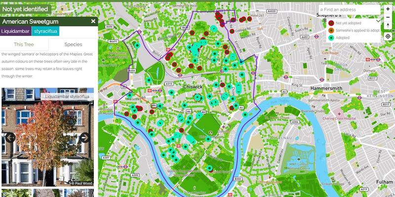
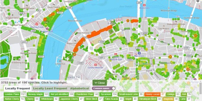
How can I highlight all the trees of a particular species?
Zoom in to the map until you see the small bar at the bottom of the map showing a count of trees. Click on the bar and it will show you a list of all the species of tree visible in the current view. Click on any of those species and it will highlight them all for you in orange.
You can now drag the map around and if any more of this species come into view they will be highlighted as well.
Some of the highlighted trees may be hidden under the bar, so may wish to drag the map or close the popup to see those.
How do I find my closest tree of a particular species?
Please see this FAQ item which shows you how to highlight trees of a particular species on the map.
I'm looking for cones or acorns. How can I find trees of a particular species near me?
Perhaps you are looking for some pine cones or for some acorns.
Or want to improve your tree Id skills and find the closest of a specific species close to you.
You can use the Species Pullup on the map to help find trees of a specific species near you.
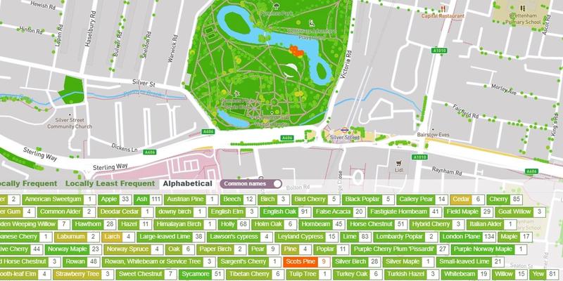
1. Go to the map
2. Zoom in fairly close to the area you want to check
3. Click on / pull up the species count bar at the bottom of the map
4. Select the options Alphabetical and Common Names
5. Look for the species you want to find in the list. For example, if you are looking for cones see if you can see PINE, SCOTS PINE, CEDAR or ATLAS CEDAR listed
(a) If you cannot see your species listed then drag the map somewhere else. It can be easier to start with a large park where there are more trees
(b) If you can see your species listed but cannot see numbers against the names then zoom in a little more (Trees will not be highlighted on the map until the count is shown). You may need to adjust the view again to bring them back into view
(c) If you can see your species listed and with numbers then you've found them!
- Click on one of those names
- Your trees are where the orange points light up!
Leave it at that zoom level and you can now drag the map around and it will light up trees of those species when any come into view.
What does 'Locally Frequent' mean?
It is the count of each species you can see inside the visible area of the map with the most frequent in that area listed first.
What does 'Locally Least Frequent' mean?
It is the count of each tree species in the visible area of the map, with the least frequent in that area listed first.
What is a 'Bronze' tree?
A tree is labelled 'BRONZE' if it is a species that is so rare in the streets and parks that we only know of around 200 or less of that species in London.
Creating Tree Walks
When I create a tree walk in Redbridge some of the trees do not show?
There is a problem with some of the tree information provided by Redbridge borough which causes some of the trees to be drawn on top of one another on the map. The description of the walk underneath the map is correct, but the route shown on the map will not be correct. We will be getting in touch with them to try and get this fixed as soon as possible!
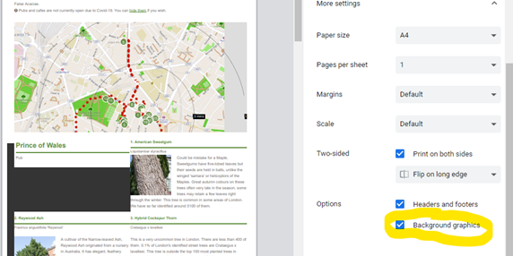
When printing it advises me to "Make sure to switch on the 'background graphics' setting". How do I do that?
This setting is required to print the map as well as can be achieved.
It is usually switched on by default. But if when you print you notice that tree numbering circles look wrong it means it is not switched on. It will still print but it is not as clear as it could be.
How it is switched on depends on the browser you are using.
1. Chrome - Press PRINT and then in the screen that appears expand the "More Settings" section and it is near the bottom of that. Make sure the setting in ticked.
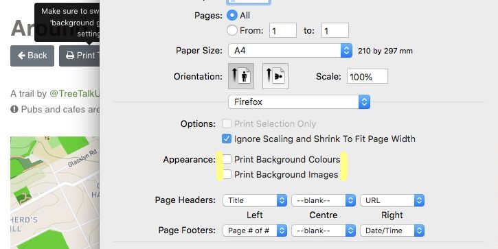
2. Safari Click Print and then make sure that the two boxes labelled 'Appearance' are ticked.
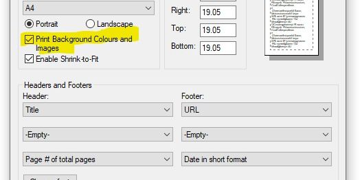
3. Microsoft Internet Explorer. Press the COG at top right of the browser, then select Page Setup... from the menu that appears. On the window that opens make sure to tick the "Print Background Colours and Images" option.
4. Firefox - Click the Firefox tab at the top left of your screen. If you don't see it, click and release the "Alt" button to see the File menu. Select Print… and select Page Setup…. Tick the Print Background (colors & images) box
5. Microsoft Edge unfortunately does not appear to support background graphics printing
Individual Trees
Your questions about individual trees and how you can get them featured.
Can you help me identify a tree?
If you are trying to identify a tree please first check whether you can find it on the map.
If not, if you are on Twitter then please share a couple of photos of the tree (ideally closeups of the leaves, bark, any flowers) with @TheStreetTree or @TreeTalkUK and where possible we will try and identify.
We're sorry but we are not able to accept identification requests via email at this time but we will try and find ways to make it easier to identify trees not already in our maps.
There is a tree missing from the map. Can you add it?
We are unable currently to add individual trees to the maps, however we are working to get lots more trees added and we are keen that everyone be given a chance to highlight and add trees. It is amazing how many trees get overlooked and we want to help share your special trees with everyone, in our tree trails!
Digging Deeper - Getting to know trees
Getting to know more about trees, their naming and all the useful things that they do in cities.
Tree's have a common name and a species name, or "Latin name". We show both on the map. Read below to understand the different forms of name you will see.
Cultivar
A cultivar is a clone of a specific selection of a species. It is reproduced clonally, typically by grafting, layering or budding. Cultivars are named, and that name is added to the end of the species name.
The Chanticleer pear which you will find throughout London is a cultivar, Pyrus calleryana 'Chanticleer'.
If a tree is a cultivar of a species you will see that cultivar name shown when you click on the tree in the map.
Genus
This is the higher classification in botanical taxonomy. Most genera contain multiple species, but some may have just one species such as Ginkgo. You will see the genus of a tree if you click on it on the map.
Species
This is the unique name that describes a type of tree within a genus, for instance Betula pendula can be broken into 'Betula' (the Birch genus) and 'pendula' (the species name for 'Silver Birch). You will see the species name if you click on a tree on the map.
Subspecies
A subspecies is usually associated with a minor distinction within a species and is usually to do with geographic distribution. For instance Populus nigra ssp. betulifolia is the Black Poplar found almost exclusively in the UK. Other very similar
Black Poplar types are found in other parts of Europe and have different subspecies designations. If a tree has a subspecies you will see it if you click on the tree in the map.
Variety
A variety is similar to a subspecies, it is a different type within a species, but unlike subspecies, it is not usually geographic, but more to do with a physical difference.
Betula utilis var. jacquemontii is a good example. It is a variety of Himalayan Birch found all over the region where the species (plain Betula utilis) is found, but has distinctive white bark not found in other types of the same species.
If a tree has a variety you will see it when you click on the tree on the map.
How is TreeTalk funded?
What is ‘Buy Me a Coffee’?
‘Buy Me a Coffee’ is a company that helps small businesses like ours by providing a facility for people to make donations. We have asked for a coffee because this is a nice way to keep us moving outdoors and creating indoors (and yes, we like caffeine too!)
Why are you asking for donations?
TreeTalk London has been created without any funding. It is the culmination of many 100s of hours of hard work. We want to continue to keep developing TreeTalk for you, and also running and maintaining the site costs money. Any donations made will contribute to the on-going growth of the project, and will be most appreciated by the TreeTalk Team.